
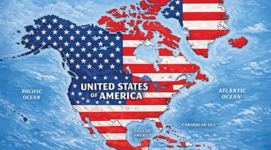
A map is the most polite form of conquest. It costs no blood and needs no army, just a pen and the nerve to use it. Donald Trump posted one of those maps on Truth Social, and on it Canada and Greenland have already come home without ever being asked. The entire area carries the words United States of America. The Gulf of Mexico is called Gulf of America on this drawing. Canada no longer appears as a country of its own, and neither does Greenland. Half a continent sits there in the colors of the American flag, still thinking of itself as independent.

Mexico isn’t treated as a clearly separate country on the map either: The colors of the U.S. flag stretch deep into Mexican territory. So Trump’s image doesn’t just target Canada and Greenland - it also deliberately blurs the line between a neighboring country and an American claim to ownership.

Mexican President Claudia Sheinbaum fires back at Trump: “Mexico is not and will not be a colony or protectorate of any foreign country. Proudly we are a free, independent, and sovereign nation.”
Renaming the Gulf is the small betrayal that gives away the bigger greed. You cannot occupy water, only rename it, and putting an owner’s name on the sea is an announcement that the land is no longer safe either. As a mere provocation, that alone would already be pretty damn heavy. Trump has been putting economic pressure on Canada for months and keeps repeating that the United States has to control Greenland. Now the same man follows it up with an image where both already seem to have happened. Talking about new borders has had enough of taking the long way through reality and is cutting straight to the picture.

Canada lies under the American flag, Greenland under the same one. Simply painting over a democratic neighbor means treating its will like a technicality. Greenland, meanwhile, is home to people nobody asked, and it belongs under a government across the Atlantic. On the map they are already Americans, in reality they never became that. Of all places, the quietest neighbor is turned by this drawing into an empty space, as if the shared history had never existed. Greenland shrinks from a country of its own into an accessory, a blank spot to color in because there is something under the ice that other people want.

A private angry citizen could draw maps like this as often as he wants. Coming from the account of a sitting president of the United States, though, what speaks through it is pretty openly the old dream of a great power that takes whatever is within reach. On paper, America First has become America Only, and neighbors now appear only as gaps in its own outline waiting to be filled. In the hands of someone who controls tariffs and fleets, the drawing becomes a program.
The timing says more than the map itself. The closer the midterms get, the bigger the territories this president has already annexed in his head. For a man who takes defeat badly, a shrinking majority at home is more frightening than any shrinking map, and so anxiety over votes makes the empire on paper grow. A map is cheaper than a policy that actually helps people, and it lights up the base more reliably. His own supporters get an empire to look at where better services would be missing, and a president who should be delivering paints instead. Anger at the neighbors costs nothing and fills the time when talking about prices and rent would get embarrassing.

Authoritarian moves first show up dressed like jokes. People laugh at the exaggeration, and the next time it comes back as a serious proposal. One image follows another, and the daily new border makes sure yesterday’s one is forgotten before anyone pushes back. The allies to the north and on the island in the ice are watching closely to see how much arrogance an American president can get away with without anything happening to him. Every missing response pushes the boundary of what can be said a little further. Today’s drawing is tomorrow’s position.
The image becomes dangerous where it stops passing as a joke. Every border held for a long time because enough people treated it as a given. His biggest gain lies in the shrug with which the map is received, because that shrug gets a country used to the outrageous. A president who recolors maps however he wants is practicing on his neighbors what he has long been doing to the rules at home. The northern border and the Constitution inside the country have the same enemy, namely the belief that power is allowed to take whatever it can reach.
Drawn claims have rarely stayed on paper. The pen runs ahead of the border, not behind it, and color on a map is the first reach for possession with men like this. Canada and Greenland are not going to become American overnight, not even this president has that much drawing talent. But the more restless the electorate gets, the less restraint he shows in painting the world the way he wants it. This map is a warning, and warnings are being ignored in America right now one after another.
Updates – Kaizen News Brief
Alle aktuellen ausgesuchten Tagesmeldungen findet ihr in den Kaizen Kurznachrichten.
To the Kaizen News Brief In English


